 Object Info
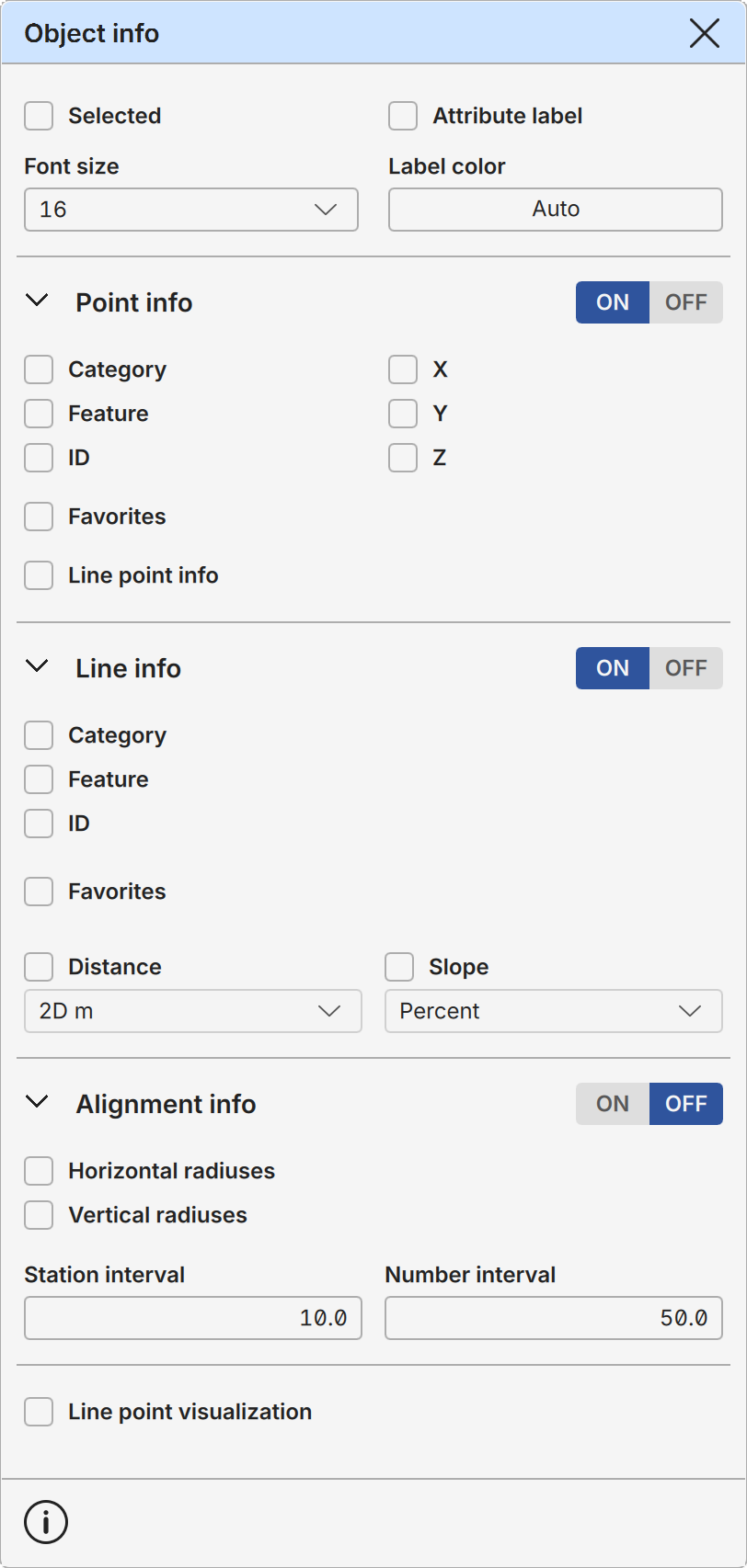
Object info settings determine how the point and line information is displayed.
There are some common options affecting all object types and object specific options for points, lines and alignments. The ON/OFF toggle setting on the title line can be used to turn object info on or off for the given object type.
Each object type section can also be collapsed and expanded using the arrow symbol beside the title. This does not affect their usage.
Info is displayed only for objects in the active element. Also, missing attributes are skipped when creating the info data block.
Selected Labels are displayed only for selected objects. This overrides all other object selection settings.
Attribute label Displays attribute name in front of the value. By default only the attribute value is displayed.
Font size Font size used for all label texts.
Label color Color used for all label texts. Primary mouse button click opens color selection tool and secondary mouse button restores Auto-mode for default color.
Point Info
Point attributes are displayed beside the points. Settings are used for both single and line points.
Category, Feature Point category and feature code.
ID Point id.
X, Y, Z Point coordinate values.
Favorites Favorites from the object properties.
Line point info Information is displayed also for line points. By default they are displayed only for single points.
Line Info
Line attributes are displayed beside the line segments. If there are more then one info line, they are divided evenly to both sides of the line. Upside down texts are automatically rotated 180 degrees to make them easier to read.
Category, Feature Line category and feature code.
ID Line id.
Favorites Favorites from the object properties.
Distance The distance between line segment endpoints. This can be horizontal distance (2D), three-dimensional distance (3D) or height difference (DZ). All options are available either in meters or in millimeters. Negative height difference is downwards and the amount of decimals is adjusted automatically.
Slope Slope of the line segment. This is available in following forms: decimal ratio (0.1234), inverse ratio (1:2.34), Percent (12.34%), Permille (123.4‰), angle in degrees (12.34°) or angle in gons (12.34g). Negative value is downwards and the amount of decimals is adjusted automatically.
Alignment Info
Alignment information is displayed beside the active road alignment. The ON/OFF toggle switch turns all alignment information on or off.
Horizontal radiuses Displays horizontal radius lines for the alignment.
Vertical radiuses Displays vertical radius lines for the alignment. Note that these are visible only in the 3D mode.
Station interval Alignment station line interval in meters.
Number interval Alignment station number interval in meters.
Line point visualization Toggles small dots at the start and end of each line segment, making it easier to see and select individual segments in a line.