 Object info
Object info settings determine how the point and line information is displayed.
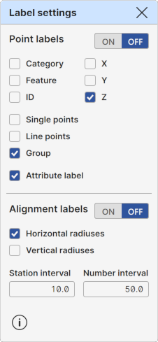
Point info
Point attributes are displayed beside the point for the active file. Settings are used for both single and line points. The ON/OFF toggle switch turns point and line information on or off.
Category, Feature Object category and feature code.
ID Object id (point or line number).
X, Y, Z Point coordinate values.
Favorites Favorites from the object properties.
By default information is displayed only for the active object. Following settings can be used to show them for other objects.
Single points Information is displayed for all single points.
Line points Information is displayed for all line points.
Selected Labels are displayed also for selected objects.
By default only the attribute value is displayed. Following setting can be used to show extended information.
Attribute label Displays attribute name in front of the value.
Alignment info
Alignment information is displayed beside the active road alignment. The ON/OFF toggle switch turns all alignment information on or off.
Horizontal radiuses Displays horizontal radius lines for the alignment.
Vertical radiuses Displays vertical radius lines for the alignment. Note that these are visible only in the 3D mode.
Station interval Alignment station line interval in meters.
Number interval Alignment station number interval in meters.
Symbols
Line points Toggles small dots at the start and end of each line segment, making it easier to see and select individual segments in a line.
Settings
Font size Font size used for all label texts.